
Introduction
Geographically Speaking What Is the Bermuda Triangle?
This term describes a region in the southwestern North Atlantic Ocean bounded by Miami (in the US state of Florida), the island of Bermuda, and the city of San Juan (in Puerto Rico). In addition to being very well-known and infamous for being mysterious, there’s lot of other stuff there, including a big expanse of open sea, strong currents and undersea formations, underwater reefs and an area of changing water characteristics and environmental conditions based on the time of year.
(The term was also a big hit on television and there’s now the “Bermuda Triangle TV show.”). Why doesn’t the “Triangle” have the same borders on all maps? Because it’s really a term that applies to a real place. It is simply how people are pointing out the place that the region covers.
The three cities mentioned are generally used as cornerstones of a triangle used to identify a vast area.
Exact Location of the Bermuda Triangle
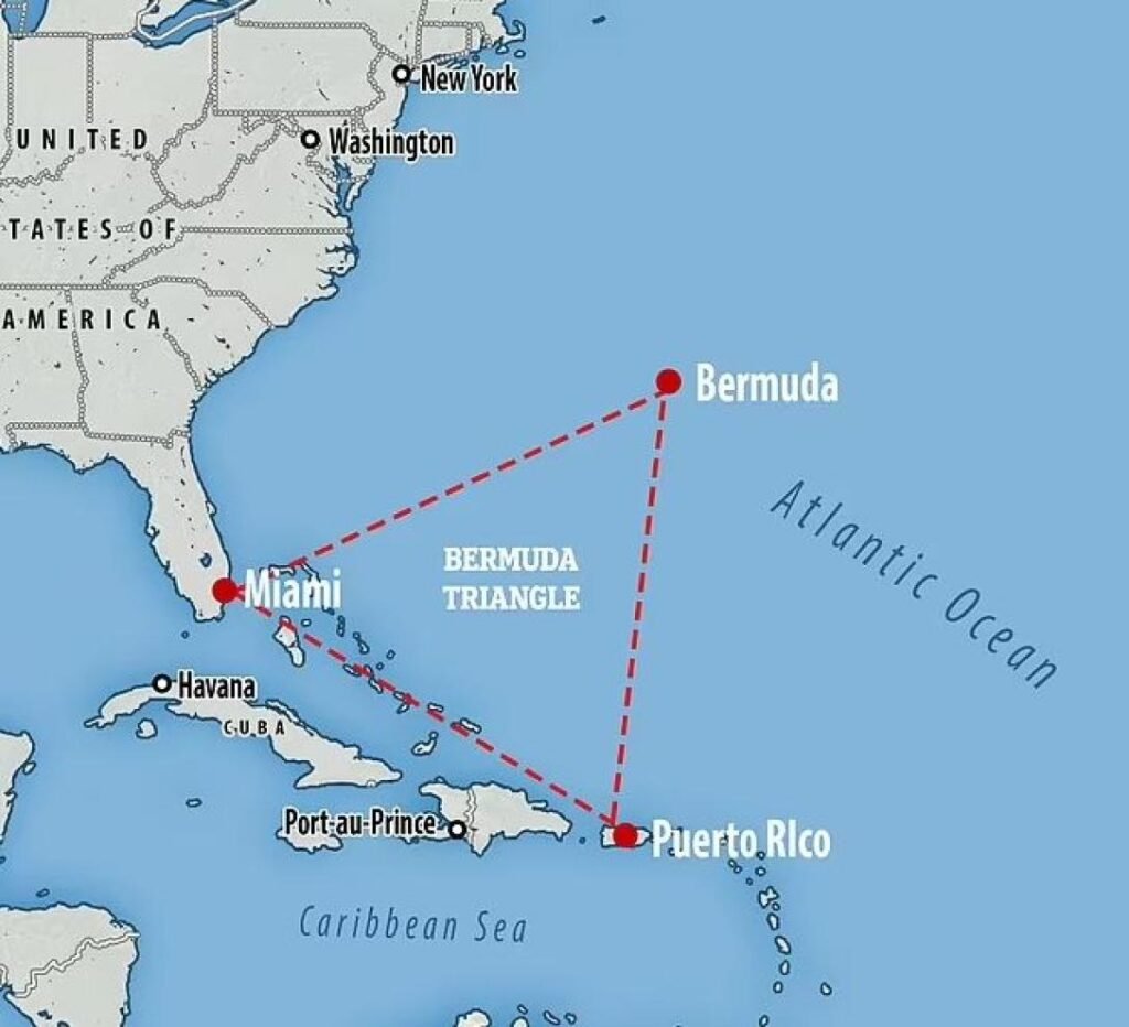
Where in the World is the Bermuda Triangle?
The Bermuda Triangle covers an approximate 50,000-mile area in the western part of the North Atlantic Ocean. Commonly agreedupon reference points include Miami, Bermuda and Puerto Rico.
The Bermuda Triangle’s common reference points create an area bordered by the following points:Miami, Florida – The southwestern point (or “leg” of the triangle).
Bermuda – the northeastern point. San Juan, Puerto Rico – the southeastern point. When connected on a map, these three points create a large triangle over the Atlantic Ocean; however, there has not been an international body of work to define this territory, and exact boundary shapes will vary slightly from reference to reference. Located somewhere between the North American mainland and the Caribbean islands, the Triangle is situated within a highly traveled area of the Atlantic Ocean both commercially and personally.
Numerous ships en route to or from Europe from North and Central America and Caribbean destinations will likely sail through these waters, and commercial jets crossing the Atlantic frequently use the airspace over this section of ocean.
Size of the Bermuda Triangle
Due to the lack of any official borders it’s quite difficult to determine how big the Bermuda Triangle really is. However estimates commonly report that the Bermuda Triangle stretches between 500,000 – 1,000,000 square miles (about 1.3 – 2.6 million square kilometers). This is the size of many countries with considerable amount of ocean, thus how large the Bermuda Triangle varies on different maps, with the region being a few more or less extended to parts of the Atlantic.
The Three Main Points
Miami, Florida
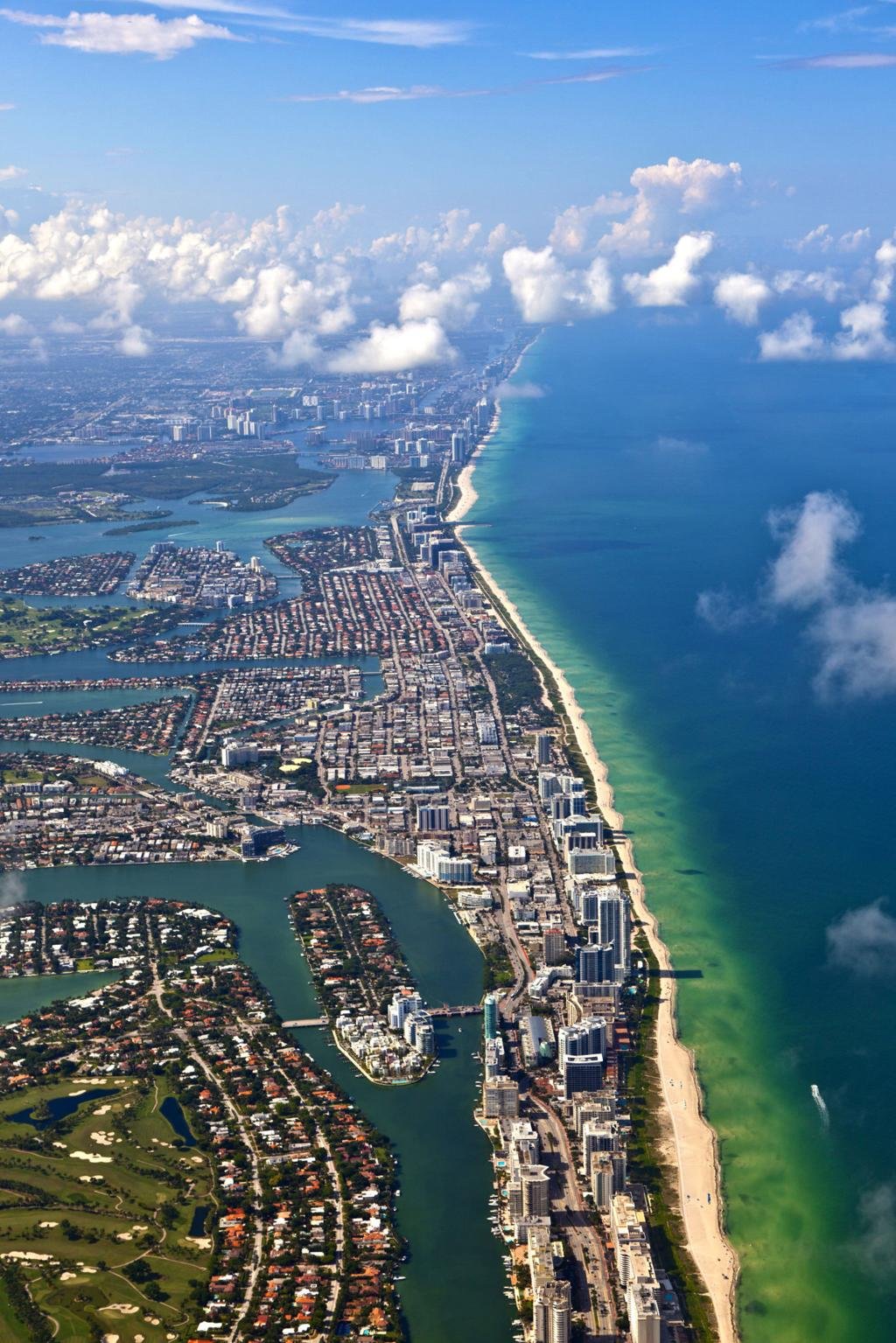
Miami represents the western point of the Bermuda Triangle. Sitting on the southeastern coast of Florida at the Atlantic Ocean, it is one of the most important shipping and air transit hubs of America. From Miami port waters flow into the Gulf Stream, the globe’s most intense current and maritime transit lane. Day-in, day-out numerous cruise and cargo ships, fishing charters and luxury motorboats sail in and out of Florida ports, this part of Atlantic Ocean shipping is most heavy.
Bermuda
Far Out in the Atlantic Far on Bermuda is the northern tip of the Triangle in the mid Atlantic, the British Overseas Territory to approximately 1000 kilometers (620 miles) east of the North Carolina coast. The island Bermuda which rises far from the mainland, protected by coral reefs and clean Atlantic blue and dramatic deep slope, is an extremely crucial oceanic position between Europe and North America.
San Juan, Puerto Rico
The base of the Triangle is San Juan. Situated on the northern coast of Puerto Rico it looks out at the Atlantic Ocean while still being on the boundary of the Caribbean.
The water is much deeper as it nears the equally nearby Puerto Rico Trench forming perhaps one of the most interesting submarine scenery in the Atlantic.
Other part of the Bermuda triangle
The bulk of the Bermuda Triangle is open water, but just below the surface it contains one of the most diverse underwater ecosystems.
The seabed includes:
- Continental shelves
- Deep ocean basins
- Underwater mountains (seamounts)
- Coral reefs
- Rocky slopes
- Deep trenches
In certain locations, the depth of water changes very quickly. The waters are quite shallow near Florida due to the edge of the continent, but then quickly fall away into much deeper waters of the Atlantic. Cliffs also rapidly drop away into the ocean around the Bermuda.
The Gulf Stream
One of the most important geographical features of the Bermuda Triangle is the Gulf Stream.
This warm, strong, ocean current originating in the Gulf of Mexico and crossing the Florida Strait then sweeps northeastward across the Atlantic.
The Gulf Stream has several important characteristics:
the current transports warm tropical water to the north.
This phenomenon can move at a speed of a few kph
It can have an effect on the weather in certain region
It influences water temperature across the Atlantic.
Currents are the most powerful natural phenomenon in the area.
The Puerto Rico Trench
In the southeast corner of the larger region is the Puerto Rico Trench, the deepest part of the Atlantic Ocean.
Its maximum depth reaches approximately:
8,376 meters or about 27,480 feet
This huge underwater trench was formed by tectonic plates shifting over millions of years. While not all maps have the trench within the Triangle, it is one of the most remarkable land features in the vicinity.
Coral Reefs and Marine Environment
Massive reef systems around the waters of Florida, Bermuda, Puerto Rico and elsewhere host thousands of marine inhabitants.
These reefs provide habitat for:
- Tropical fish
- Sea turtles
- Sharks
- Rays
- Lobsters
- Coral species
- Marine plants
The warm waters of the Atlantic Ocean make this area one of the most diverse in the western Atlantic.
Water Temperature
Since Bermuda Triangle is within tropical and subtropical region, it has warm ocean water for most yearround.
Average sea temperatures generally range from:
- Winter: around 22C (72F)
- Summer: around 29C (84F)
These warm waters sustain marine life while fueling tropical weather systems.
Climate of the Region
The Bermuda Triangle is in a region affected by both tropical and subtropical weather.
The area experiences:
- Warm summers
- Mild winters
- High humidity
- Seasonal rainfall
- Tropical storms
- Hurricanes
Weather can be unpredictable and change rapidly – especially during the Atlantic hurricane season June-November.
Seasonal Changes
Different parts of the region change all year.
- Spring
- Warmer ocean temperatures
- Increasing marine activity
- More stable weather
- Summer
- Highest water temperatures
- Increased humidity
- Greater chance of tropical storms
- Autumn
The season of the cyclone.
The ocean stays hot.
Weather systems gets stronger and more frequent.
Winter
The waters at a bit cooler but still quite warm.
- Strong Atlantic winds
- Improved visibility on many days
- Nearby Islands
There are many island groups that are located just outside or bordering the Bermuda Triangle.
These include:
- Bermuda
- The Bahamas
- Puerto Rico
- Turks and Caicos
- Various smaller Atlantic islands
The islands offer a contrasting type of coast which is not so common, to the open ocean between them.
Marine Life
In waters of the warmest temperatures on the planet, the region provides a habitat for incredible variety of life.
Common animals include:
- Dolphins
- Whales
- sea turtles
- Flying fish
- Tuna
- Marlin
- Sharks
- Stingrays
Ocean Depth Variations
The fascinating thing about the geographical features is the rapidity at which the depth of the ocean varies.
Near Florida:
- Shallow coastal waters
- Continental shelf
Farther east:
Quickly fall into an abyss of deep Atlantic waters
Near Puerto Rico:
- Extremely deep ocean terrain
This intense underwater activity makes the area geologically diverse.
Why the Area Is Geographically Important The Bermuda Triangle is located on one of the busiest trade routes in the Atlantic.
Its location connects:
- North America
- The Caribbean
- Europe
- Central America
Due to its strategic position, the larger region is frequented by mass shipping routes and worldwide flight lines.
Modern Mapping of the Region
With the modern day use of satellites, GPS technology, and sophisticated ocean mapping, the geography of the Bermuda Triangle has been remarkably enhanced.
Scientists can now study:
- Ocean currents
- Seafloor structures
- Water temperature
- Weather systems
- Marine ecosystems
While still popular in pop culture, today’s geographers recognize the Triangle as a sizable area of the western Atlantic composed of various oceanic features, and is not officially designated territory.
Conclusion
Geographically, the Bermuda Triangle is one of the most fascinating regions of the entire Atlantic Ocean. The roughly hundreds of thousands of square miles of water located somewhere between Miami, Florida, Bermuda, and Puerto Rico feature strong current such as the Gulf stream, vast deep ocean basins, coral reefs, highly variable depths, and a warm climate which dictate many of the natural characteristics of sea life and weather events in the triangle. While it has never been formally demarcated, with the geography, location and nature of the triangle, a large area in the North Atlantic may one day rise to claim more prominence within the region.
Nice and informational content
Bhai itna badhiya content kese likhte ho